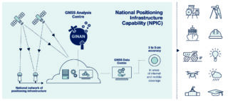
Developing and incorporating Low Earth Orbiter (LEO) GNSS data analysis capability into Ginan
GNSS-SPAN has won a project from Frontier SI to develop the precise orbit determination (POD) feature for the LEO satellites in Ginan software. Ginan is Geoscience Australia’s software to perform various positioning and navigation scenarios, produce real-time corrections, and in the future, perform LEO POD.
Dr Amir Allahvirdi-Zadeh will work directly on this project in line with the GA Ginan team and a team from the University of Newcastle. Prof. Ahmed El-Mowafy will supervise the project from the Curtin team. This is the first time in Australia that such advanced algorithms will be implemented in real-time software with a highly efficient programming language (C++). The POD feature will be useful in various processing and analysis scenarios for the users of Ginan and will have an important role in future LEO PNT applications.