CORS Network
CORS Network Real-Time Kinematic Positioning
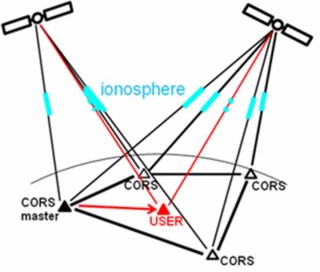
CORS Network RTK is a concept in GNSS Geodesy/Surveying/Positioning that enables users (e.g. moving platforms) to position themselves with high-precision (cm-level). In order to make this possible an array of permanent GNSS tracking stations (the Continuously Operating Reference Station Network) need to be available for collecting and processing the data. CORS Network RTK will become more important for Australian users as new CORS infrastructure is being realized (e.g. AuScope).
The steps for CORS Network RTK are:
- Collection and cleaning of carrier phase and pseudorange data at all CORS stations
- Network processing using a priori information of station coordinates and GNSS orbits with the goal of producing very precise estimates of ionospheric delays
- Generation of ionospheric corrections for mobile users by interpolation of the CORS network ionospheric delays
- Precise user GNSS positioning/navigation by applying the CORS ionospheric corrections
We are currently developing the concept of ionospheric tomography in order to speed up the network processing and to improve the quality of the ionospheric corrections as disseminated to users. Tomography-based modeling will become even more important in the light of the future new GNSSs, such as Galileo and Compass, having as result that the ionosphere becomes intersected by many more lines-of-sight than at present using GPS only.